
Gulf disturbance could bring weekend rain to Durham
Invest 92L could bring rain to Durham this weekend. Forecasters aren’t predicting hazardous weather here right now, but residents should keep an eye on the forecast as the week goes on.

 Wes Platt
This story reflects official forecasts issued Tuesday morning, Oct. 6, 2026.
A developing tropical disturbance in the Gulf of Mexico could bring rain to Durham this weekend, but the National Weather Service isn’t forecasting hazardous weather for central North Carolina at this point.
Residents should keep an eye on the forecast as the week goes on. The system’s path is still uncertain, and forecasters haven’t settled how much rain it could bring to the area.
NWS Raleigh expects much of the week to stay dry. Its Tuesday morning forecast discussion identified Saturday night, Oct. 10, through Monday morning, Oct. 12, as the period when the most significant rain could fall across central North Carolina, with rain chances highest Sunday. Forecasters noted substantial disagreement among computer models about the developing Gulf system.
“No hazardous weather is expected at this time,” the weather service wrote in its hazardous weather outlook issued at 2:15 a.m. Tuesday. That assessment covered Durham County and the rest of central North Carolina through Monday. The office’s 5:40 a.m. forecast discussion listed no watches, warnings, or advisories.
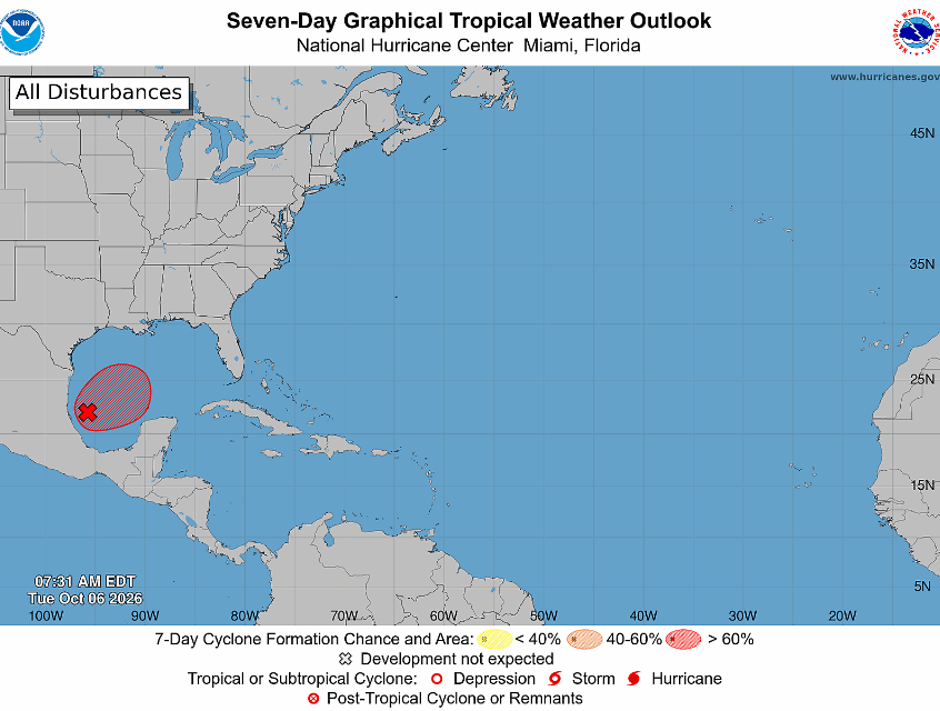
The disturbance, known as Invest 92L or AL92, was showing signs of organization over the southwestern Gulf Tuesday morning. At 8 a.m., the National Hurricane Center gave it a 90% chance of developing into a tropical cyclone - it would be named Isaias - within 48 hours and expected a tropical depression to form within about a day.
“Invest” is a tracking label forecasters use for a tropical disturbance they’re investigating.
The hurricane center expects the system to drift eastward before turning north or northeast toward the northern Gulf Coast late this week. Specific effects along that coast remained uncertain Tuesday morning, and the center advised people from Louisiana to the Florida Panhandle to monitor its progress.
For Durham residents, particularly those with outdoor plans this weekend, the next few days of forecasts will help with planning. Watch for changes in rain timing, expected rainfall amounts, and local weather alerts.
Get Connected

- Send email to your neighborhood news guy: wes.platt@southpointaccess.news
- Follow on Threads.
- Connect on Instagram!
- Join our Discord community
- Join the Southpoint Access subreddit!
 Wes Platt
🤝 Support Our Sponsors
Local journalism in South Durham survives thanks to the generous businesses and organizations that make this work possible. 🧭
By supporting these sponsors, you’re helping Southpoint Access continue to deliver trusted, hyperlocal news and resources for our community - from school updates to neighborhood stories that keep South Durham connected.
Want to become a sponsor? Sign up here!
💛 Shop local. Hire local. Support those who support Southpoint Access.





![[SoDu We Learn DPS Governance] What Test Scores Tell a DPS Board Member, and What They Don’t](https://storage.ghost.io/c/50/33/50334374-93a7-4cf9-ba69-d7d51c63be2a/content/images/size/w600/2026/10/dpsgovernance5.png)
![[SeeGov Enhanced] Durham approves Wake Forest Highway housing over neighbors’ objections](https://storage.ghost.io/c/50/33/50334374-93a7-4cf9-ba69-d7d51c63be2a/content/images/size/w600/2026/10/wakeforesthighway.png)
![[In Memoriam] Durham obituaries updated with services scheduled through Oct. 17](https://storage.ghost.io/c/50/33/50334374-93a7-4cf9-ba69-d7d51c63be2a/content/images/size/w600/2026/10/obituaries--1-.png)