
Isaias nears Gulf Coast; Durham’s rain could last through Sunday night
Isaias is nearing the Gulf Coast, and Durham’s weekend rain could linger through Sunday night. Here’s what to know about rainfall, storm risks, and outdoor plans.

 Wes Platt
This story reflects the National Hurricane Center’s 8 a.m. EDT advisory and NWS Raleigh’s 6:20 a.m. forecast discussion.
Durham’s weekend forecast calls for rain into Sunday night as Hurricane Isaias approaches the northern Gulf Coast. Central North Carolina could receive 1 to 2 inches, with localized flooding possible in urban areas and places with poor drainage.
The National Weather Service expects rain chances to increase Saturday afternoon, Oct. 10, with widespread rain Saturday evening and Sunday. A brief break around midday Sunday could be followed by another band of showers and storms that afternoon and evening. Clearing is expected overnight into Monday, with sunshine returning Monday afternoon.
For South Durham residents making outdoor plans, that means a lull Sunday shouldn’t be treated as the end of the rain.
There's no immediate weather emergency here. NWS Raleigh listed no watches, warnings, or advisories in its 6:20 a.m. Friday forecast discussion. Its hazardous weather outlook says hazardous weather isn’t expected Friday.
 Wes Platt
Sunday deserves attention, though. The outlook includes Durham County in an area with a marginal risk of severe storms capable of damaging winds and possibly a few tornadoes. Forecasters place the greatest risk along and east of U.S. Highway 1. The regional forecast discussion describes the severe storm threat as low overall, with the main concern farther east and southeast.
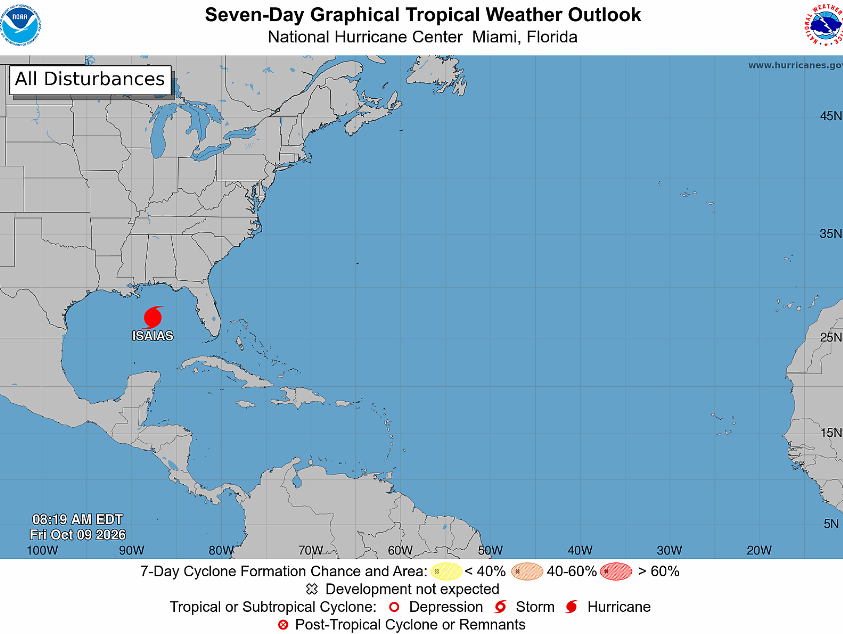
Over the Gulf, Isaias had sustained winds of 110 mph at 8 a.m. Friday, Oct. 9. Its center was about 245 miles south of Pensacola, Florida, moving north-northeast at 15 mph. The National Hurricane Center expected it to become a major hurricane Friday morning and remain dangerous at landfall Friday night or early Saturday.
Hurricane warnings extend from Ocean Springs, Mississippi, to Florida’s Bay/Gulf county line.
After landfall, the storm’s remnants are expected to move through the Tennessee Valley, well west of Durham, while sending tropical moisture into the Carolinas.
Get Connected

- Send email to your neighborhood news guy: wes.platt@southpointaccess.news
- Follow on Threads.
- Connect on Instagram!
- Join our Discord community
- Join the Southpoint Access subreddit!
 Wes Platt
🤝 Support Our Sponsors
Local journalism in South Durham survives thanks to the generous businesses and organizations that make this work possible. 🧭
By supporting these sponsors, you’re helping Southpoint Access continue to deliver trusted, hyperlocal news and resources for our community - from school updates to neighborhood stories that keep South Durham connected.
Want to become a sponsor? Sign up here!
💛 Shop local. Hire local. Support those who support Southpoint Access.





![[SoDu Crime Watch] Vehicle-related theft leads latest update](https://storage.ghost.io/c/50/33/50334374-93a7-4cf9-ba69-d7d51c63be2a/content/images/size/w600/2026/07/crimewatch--1-.png)

![[Nerdspresso] 'Cocaine Bear' and the thrill of a first R-rated movie](https://storage.ghost.io/c/50/33/50334374-93a7-4cf9-ba69-d7d51c63be2a/content/images/size/w600/2026/10/cocainebear1.jpg)
![[SeeGov Enhanced] Durham council mourns fallen firefighter, debates encampment response](https://storage.ghost.io/c/50/33/50334374-93a7-4cf9-ba69-d7d51c63be2a/content/images/size/w600/2026/10/andrewbrokes.jpg)