Weekend rain more likely for Durham as Isaias forms in Gulf
Making outdoor plans this weekend? Rain looks more likely for Durham as Tropical Storm Isaias develops in the Gulf. There aren’t any local watches or warnings right now, but keep checking the forecast as the week goes on.

 Wes Platt
This story reflects official forecasts issued Wednesday morning, Oct. 7, 2026.
Durham’s chances of weekend rain have increased as a disturbance in the Gulf became Tropical Storm Isaias early Wednesday.
Local forecasters haven’t issued weather watches or warnings, but residents should keep checking the forecast as the storm develops.
The National Weather Service in Raleigh projects around 1 inch of rain across central North Carolina. That’s a preliminary regional estimate, and totals could change with the storm’s path and speed.
Much of the remaining workweek should stay dry. Showers are expected to become more likely Saturday, Oct. 10, and continue into Sunday, with some possibility of thunderstorms.
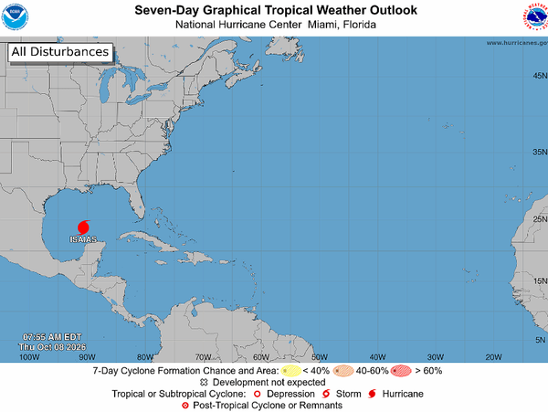
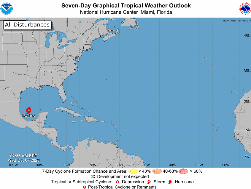
The storm was previously tracked as Invest 92L. At 5 a.m. EDT Wednesday, Isaias had sustained winds of 40 mph and was moving east-northeast at 8 mph, about 580 miles southwest of the mouth of the Mississippi River.
The hurricane center expects rapid strengthening, with Isaias becoming a hurricane by Thursday. Its Wednesday morning forecast calls for peak sustained winds of 110 mph early Friday over the Gulf.
Isaias is expected to turn northeast, then north, on Thursday and Friday before approaching the northern Gulf Coast. Forecast positions put the center inland in southern Alabama early Saturday, suggesting a coastal approach near Alabama and the western Florida Panhandle.
That track has shifted east since the previous advisory. Forecasters cautioned that confidence remains below average because computer models disagree about both the route and the timing.
The hurricane center said hurricane and storm surge watches would likely be needed for parts of the northern Gulf Coast later Wednesday. It advised residents from Louisiana to the Florida Panhandle to monitor updates and review their hurricane plans.
For Durham, NWS Raleigh is considering a scenario in which the remnants travel west of the Appalachians. Rain could reach this area well away from the center. Faster movement could help limit rainfall totals.
The office listed no watches, warnings, or advisories in its 7:02 a.m. discussion. Its earlier hazardous weather outlook, issued at 3:12 a.m., identified no hazardous weather for central North Carolina at that time.
Get Connected

- Send email to your neighborhood news guy: wes.platt@southpointaccess.news
- Follow on Threads.
- Connect on Instagram!
- Join our Discord community
- Join the Southpoint Access subreddit!
 Wes Platt
🤝 Support Our Sponsors
Local journalism in South Durham survives thanks to the generous businesses and organizations that make this work possible. 🧭
By supporting these sponsors, you’re helping Southpoint Access continue to deliver trusted, hyperlocal news and resources for our community - from school updates to neighborhood stories that keep South Durham connected.
Want to become a sponsor? Sign up here!
💛 Shop local. Hire local. Support those who support Southpoint Access.





![[SeeGov Enhanced] Durham council mourns fallen firefighter, debates encampment response](https://storage.ghost.io/c/50/33/50334374-93a7-4cf9-ba69-d7d51c63be2a/content/images/size/w600/2026/10/andrewbrokes.jpg)
![[SoDu We Dine] Two South Durham restaurants receive B grades in latest inspections](https://storage.ghost.io/c/50/33/50334374-93a7-4cf9-ba69-d7d51c63be2a/content/images/size/w600/2026/10/diningguide829.png)
![[SoDu Stuff to Do] Your Weekend Ahead - Oct. 8, 2026](https://storage.ghost.io/c/50/33/50334374-93a7-4cf9-ba69-d7d51c63be2a/content/images/size/w600/2026/06/stufftodo618.png)